Day 20 of C2Cx2 – Ennerdale to Stonethwaite, Friday 19 September 2014.
Statistics:
distance - 15 miles
moving speed – 2.7 mph
start – 8.30 am
finish – 5.45 pm
moving – 5h 30m
We breakfasted early at 7.30. Mary had bacon and baked beans and Graham had his usual English breakfast, except that this version was larger than usual. The van left at 8.20 to take us back to Ennerdale Bridge.

'Stork Hotel van ready to take us back to Ennerdale Bridge'
We resumed the walk at 8.30 under a bright blue sky. We passed an older gentleman with a backpack and towing a wheeled suitcase along the road. We chatted briefly and were told he was heading for the Ennerdale Youth Hostel for a few days rest. When we were out of sight we looked gravely at each other, both thinking he would have difficulty making the five miles.

'The road to Ennerdale Water'
On our 2010 C2C we had taken the northern route around Ennerdale Water to avoid the wet southern path after heavy rain. Wet creek crossings wouldn't be a problem this time. Our friends that we had met at Boot had taken the southern route on their recent C2C and considered it rough, rocky and steep in places with no advantage over the northern route. So we took the northern route again so it would be easier on Mary's feet. The reflections were wonderful. At the end of the lake we met the older gentleman sitting at a picnic table admiring the view. 'What's been keeping you?' he asked with a twinkle in his eye. He had caught a lift with the Sherpa Van, and had booked them to take his cases back to Ennerdale Bridge after his stay. We enjoyed his sense of humour, wished him well and pressed on.

'Anglers Crag reflections on Ennerdale Water'

'Farmhouse by Ennerdale Water'
To vary our route from our previous C2C, we crossed the River Lisa at the end of the lake to follow a forestry track rising above the southern bank of the river. As we traversed the end of the lake we met the Tassie two coming the other way along the traditional C2C route and had a brief chat. After walking for half an hour through a forested area with some tree dieback, we came across an area that had been felled leaving an open view across the valley. We used some cut stumps as table and chairs for our morning tea, looking across the valley to the youth hostel outside of which we had our morning tea four years ago.
We left the forest track along a very pretty footpath past Moss Dub. However, there were some steep ups and downs on the narrow path so we reverted to the forest track. Coming the other way along the track was a well-built bloke with a big dog walking at a cracking pace – it wouldn't have been a big deal except that he had a prosthetic leg and was walking with the aid of crutches. His build, bearing and determination suggested a military background. Our admiration was enormous and our trivial foot pains were put into perspective.

'The pretty path near Moss Dub'

'Forest track on the southern side of Ennerdale, Haystacks on the horizon'
We crossed the river over a bridge to rejoin the C2C route under Pillar. It was very hot on the northern side of the river out of the shadow of the Pillar ridge. A Landrover passed us raising a cloud of dust as we neared the wettest part of England. Views up the valley framed by rows of mountains were magnificent.

'Bridge over River Lisa'

'A passing vehicle raises a cloud of dust in the wettest part of England'
With Black Sail Hut in sight we turned up the path to Scarth Gap. We stopped at the Gap at 1.15 for lunch and were passed by another group of DoE walkers. We gazed up at the rocky outcrops of Haystacks that had almost stopped Mary in 2010. Mary was determined to conquer Haystacks this time. We watched a large group of walkers concertina at the steep section that Mary had found difficult. This time Mary scrambled up the steep section unaided, and she was very proud of her achievement.

'Climbing the path to Scarth Gap'

'Lunch at Scarth Gap looking up at Haystacks'

'A group of Duke of Edinburgh Award expeditioners'

'Mary scrambles up Haystacks'
We shared the top of Haystacks with 30 other walkers. We descended to Innominate Tarn, passing more walkers on the way. Wainwright's final resting place was as beautiful as we remembered it. We followed the rocky path to Dub's quarry, avoiding the path down to Buttermere that lured us in 2010. The rocky descent to Honister slate mine was slow and painful – our feet were unhappy. We were not as unhappy as some members of a large walking party slogging up the hill at the end of a long walking day. We stopped at the mine for a cold drink.

'Haystacks summit'

'Innominate Tarn'

'View to distant Fellbarrow ridge, our first Wainwright walk'

'Slate spoil, Dub's quarry; path winding back to Haystacks on right'

'Tramway leading over the edge to the slate works'
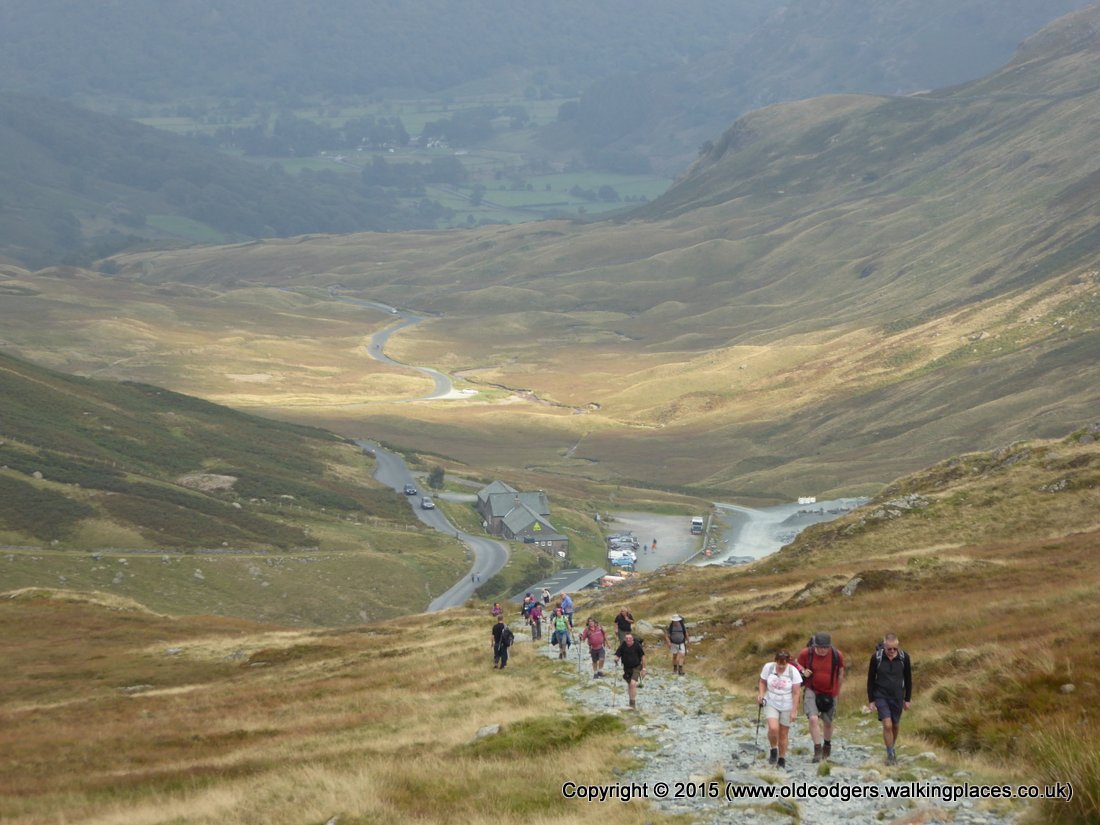
'A walking party climbs from Honister slate mine'
Mary was more unhappy when we had to follow the chain route across the rocky outcrop in Johnny's Wood. We took several shortcuts bypassing Seatoller and Rosthwaite and heading directly for Stonethwaite. We arrived at Stonethwaite Farm, our B&B, at 5.45. We unpacked and showered in our tiny room and tiny shower. The B&B had booked a table for us at the Langstrath Hotel for dinner. Graham began with an Old Peculier (great) and then tried a Jennings Crackerjack (very good). The restaurant had great views up the Greenup Valley, and great food – starters of olives, peppers and tomatoes, mains salmon fillet with roasted potatoes and pork medallions on crushed potatoes with a mustard sauce. After a very enjoyable evening we retired to bed at 9.15.
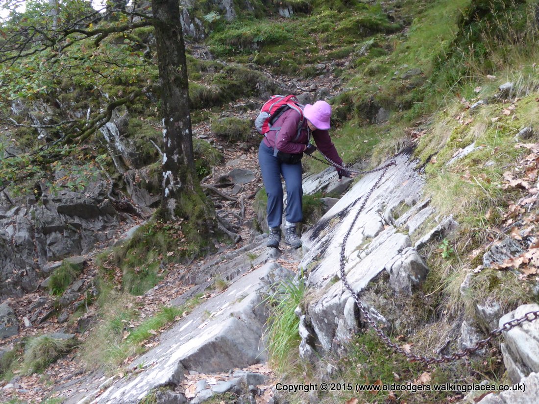
'Mary traverses rocky outcrop, Johnny's Wood'

'On our way to dinner at Langstrath Hotel, Stonethwaite'